The Northwest Busway reached a major milestone yesterday with the official opening of the first permanent piece of busway infrastructure – the Westgate Te Waiarohia Station. (See details here about services, and ministerial media release here.)
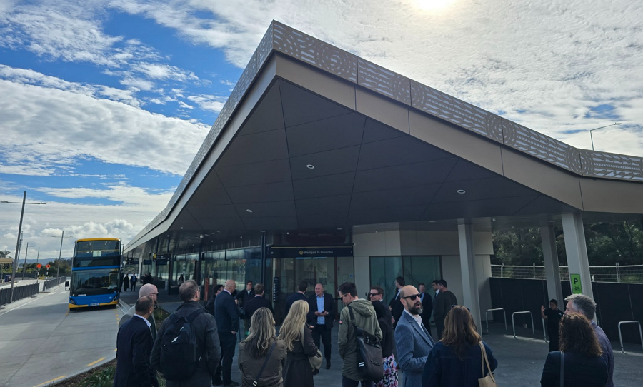 The rapid transit service that will run on the future Northwest Busway – the WX1 – was launched in late 2023 with interim stations on the Te Atatū and Lincoln Rd motorway interchanges and just some basic bus-stops at Westgate. And already, without a proper busway to run on, it has been incredibly popular.
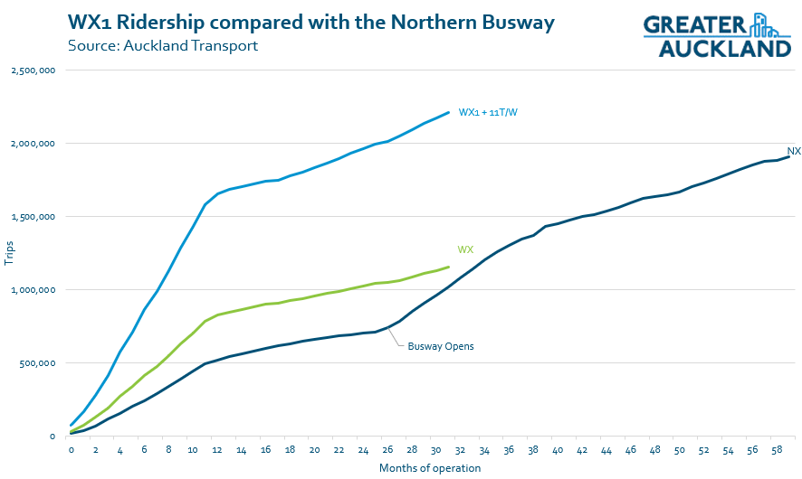
In its first year, the WX1 carried over 800,000 trips, which is 40% higher than forecast. As of the end of June, that is now up to 1.16 million annual trips – and it is still growing by over 20% annually. Clearly there was a lot of suppressed demand.
As a reminder, the Northern Busway started in a similar fashion: the Northern Express buses ran through the Albany and Constellation stations to the city before the construction of the first stage of the busway proper and other busway stations. And many months after the Northern Busway opened, ridership reached the level the WX1 is already achieving.
Further underscoring the latent public transport demand in the northwest: the number of people using northwest buses almost doubles if you include ridership of the 11T/W buses. These run a parallel route – but on local roads – from Westgate to Lincoln Rd, and from Pt Chevalier to the City.
I suspect at least a decent chunk of the trips on the 11 routes would shift to using the WX1 if the full NW Busway was in place. Regardless, these routes combined are now some of the busiest in the region.
Here’s how that looks on a chart, across months of operation, with the WX in green, and WX + 11 T/W in light blue, and – for comparison, the NX in dark blue. Spot how the opening of the Northern Busway accelerated NX ridership. But also look how high ridership is from the Northwest.
At the opening of the station yesterday, it was noted that:
“Westgate Station is expected to serve approximately 1,000 passenger journeys per day at opening, with usage forecast to grow to more than 13,000 passenger journeys per day by 2041.
At the opening, both Transport Minister Chris Bishop and Mayor Wayne Brown spoke.
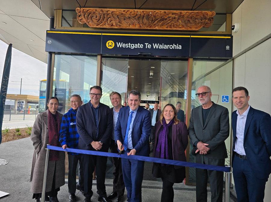
Bishop’s speech was very good. He spoke about how the age of motorways is over for Auckland – save for a few minor tweaks – and how projects like the Northwest Busway are the future, to give Aucklanders better options to get around the city. Unfortunately, only a little bit of that speech is captured in his press release.
“Our Government has been clear and unapologetic about the priorities for public transport investment through the Government Policy Statement on land transport and the recently released Major Transport Projects Pipeline,” Mr Bishop says.
“Today is an exciting step in the staged delivery of the wider Northwest Busway project and demonstrates our commitment to investing in practical and value for money infrastructure that delivers better transport choices.
“Once fully completed, the Northwest Busway will be a transformational piece of infrastructure for northwest Auckland, with the ability to move up to 9,000 passengers per hour in each direction, the equivalent of four motorway lanes.
The Minister also posted this impressive one-take shot to Instagram about the station.
View this post on Instagram
Mayor Wayne Brown, when not throwing barbs at the various government ministers in attendance and their ‘Roads of National Party Significance’, was effusive about the station – especially the fact that it wasn’t overengineered.
“I’ve been a strong supporter of the Northwest busway as it provides people who live in the North-West faster, regular services and a strong alternative to the heavily congested North-Western motorway.
“There is clearly a demand for public transport in the North-West, given the success of the Western Express bus service launched using low-cost improvements, which aligns to my focus of getting things done better, cheaper, faster, to get Auckland moving.
“I’m pleased to see the bus station has been designed using standardised components with a better, cheaper, faster view of the costs and I’m assured this is not another cathedral.
The station itself is really nice, and some of the detailing makes it probably a little bit nicer than the Northern Busway stations.
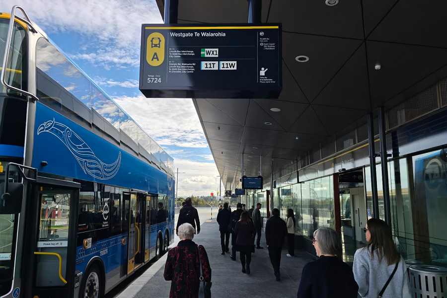
I wish the shelter extended a bit closer to the bus. Also why can’t we get platform length shelters on most train station platforms?
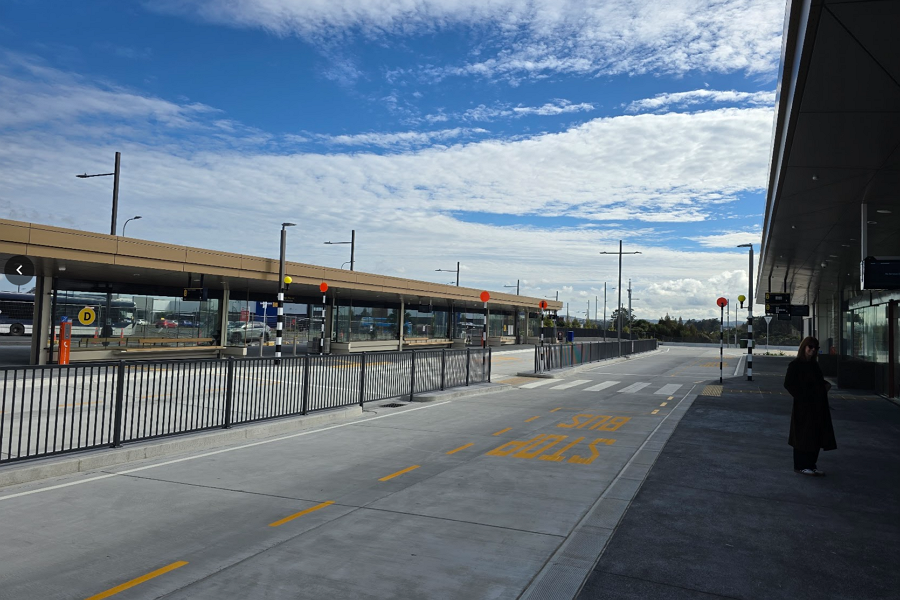
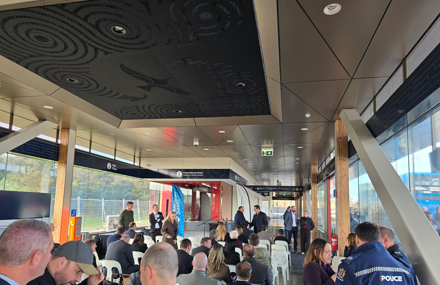
I like the carved wood panelling on the beams
When the NW Busway itself is built, new platforms will be added on to what is currently the back side of the station, and the bus stops that have just been completed will be used for local services.
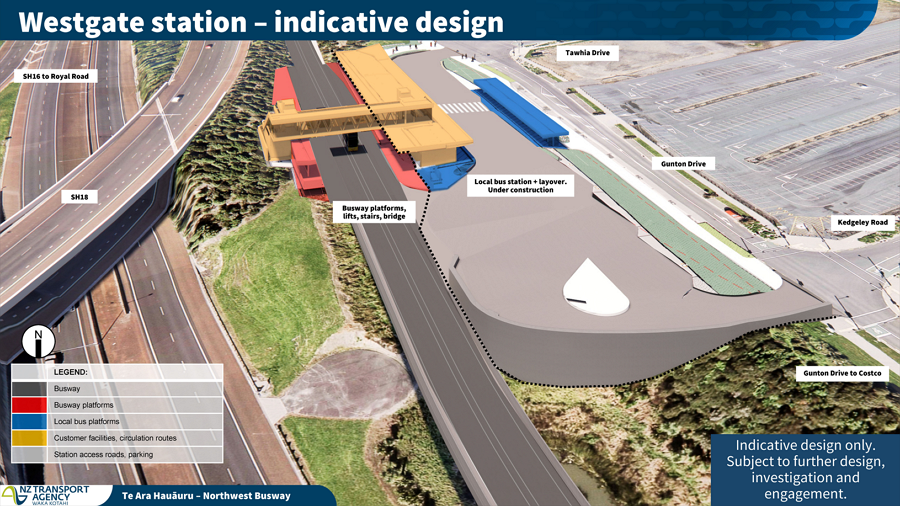
Impressively, the project came in well under budget: originally planned to cost $50 million, the station has come in $19 million below that. Even better news is that the money saved is going to be put towards further improvements for the Northwest:
- Some targeted improvements to the Newton Rd ramps to speed up buses on what is currently one of the most unreliable parts of the journey.
- Helping fund the Brigham Creek Station, for which enabling works are expected to start early next year, with the station due to open in early 2029.
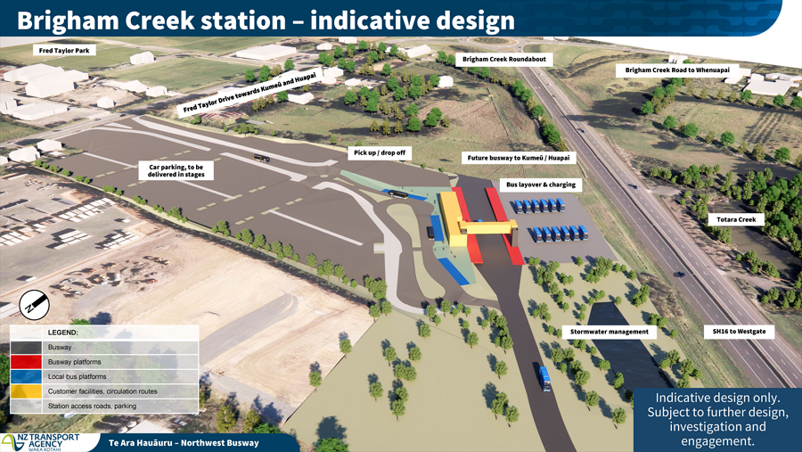
The new station will be open to passengers from this coming Sunday 16 August.

 Processing...
Bus lanes, whether on the shoulder or a peak flow centre running one, are desperately needed all the way out to Kumeu to give the long suffering commuters there a chance
Poor commuters haven’t had their motorway widened since 2013
Putting a proper Busway in all the way to Waimauku and leaving the SH16 carway as it is would meet the needs of the Northwest far better and far sooner than waiting until a Motorway with shoulder running busway can be justified and funded.
Yes, building the rtn connection first would solve most of the issues and delay the need for much larger spending on extending the motorway
Yes I agree but we are at the stage where the motorway is needed and the congestion is unlikely to be that bad once this is built so the busway would be a waste of money but start building nicer stations and more park n rides for a start.
“….the busway would be a waste of money.”
Did you read those growth statistics and forecasts?
“James” can’t read anything that debunks their ideology.
The brigham creek station seems to only make sense if it is connected by busway to westgate? So is that in scope by 2029?
Unfortunately not at this stage, only when funding is available.
My understanding is initially buses was head along Fred Taylor Dr and that AT are looking to add the intersection for Te Mara Rd which would allow buses to use that to get to the station. Not perfect but probably okay as an initial outcome.
A big focus of the team developing the busway is to be able to break it up into stages so they can chip away at delivery as bits of funding becomes available than rather than having to get a massive upfront cost agreed to.
In terms of getting things done better, cheaper, faster, it seems to me there are opportunities to improve bus priority on the motorway right now, such as some sort of clearway by the Patiki onramp. Would be keen to hear what opportunities are viable!
“Our Government has been clear and unapologetic about the priorities for public transport investment.” Maybe about time for an apology for Te Hana and cuts to PT and active modes.
But really good to see recognition of what this start enables. Bus from Redhills Precinct to City Centre destinations now matching car trip for time and exceeding for relaxation and enjoyment.
The subtle station architecture provides light and temperature/ ventilation management, with lessons learned from all previous stations.
Personally I am disappointed that the NW Busway is being built as Trunk and Feeder when Direct Service busways appear the more popular option for high volume busways. https://unfccc.int/climate-action/momentum-for-change/urban-poor/guangzhou-bus-rapid-transit-system
It is a direct service busway. Local buses can join at Ian McKinnon, Te Atatu, Westgate, and Brigham Creek. Both of Auckland’s existing buseays are direct service. There are almost a dozen services running on the two busways and all of them do more than 50% of their route on the busway.
AT run (and are proposing to continue) a frequent model where you run fewer high frequency bus routes meeting at hubs rather than 2000 routes running everywhere to everywhere, but only going 4 times a day. When AT switched to a frequent model, they achieved a massive increase in ridership.
The Northern Busway is largely Trunk and Feeder, and to travel from the CBD to the suburbs by bus you have to get off and transfer on the busway. The North Western is planned to run 150 seat buses only using the NW Busway and running them through the CBD. At high (6,000 people per hour) volumes hub and spoke busways struggle because the amount of transfers choke the busway stations.
Sorry should have been more specific. Currently the NW busway has some direct services. The new plan is to be entirely trunk and feeder. On the Northern busway by running the NX1, NX2 and 866 to different CBD sites the buses are direct service in the city but on the North Shore none leave the busway. The problem is when you get over 6,000 people per hour using a busway the mechanics of boarding unloading start to limit increased service. Direct Service can relieve this and increase a busways capacity. A busway expert estimated15,000 per hour using this method.
The NX1, NX2, and 866 all good to non-busway destinations at both ends (Silverdale, Albany Village and soon Whangaparaoa; Waitemata, Universities, Newmarket). The 83 also uses the busway for the middle section of it’s route.
This is what a direct service busway looks like; several frequent routes that converge on the core busway section.
Tge northern busway actually had much more capacity issues before the network changed to a frequent model because all the half empty buses on the L shaped routes clogged up every stop. Loading and unloading was much worse because passengers had to wait a long time for the ‘correct’ bus to show up.
Trans Millenio in Columbia runs a direct service pattern and its capacity is now severely limited by platform overcrowding.
Out west, the 149, 11T, and 11W all use parts of the busway. There is no indication that this will stop when the interim busway is upgraded. Nor is there any suggestion that the 70, 72, or 712 will significantly change when the eastern busway opens.
i remember when the 881, 991X and 992X were completely full before they even got to Smales Farm
not sure a singular website counts as the definitive word on whether hub and spoke or direct service is better
Guangzhou’s BRT has itty bitty bus stop style stations with a 4-6 lane wide busway in the middle of a stroad. Auckland’s busway stations are of a design much more like a train station, there’s a significant waiting area, and local bus stops are spread out over 2 or even 4 platforms. The closest thing we have to Guangzhou’s stations are the local stop for Williams Ave on the Eastern Busway, where transfers between services probably aren’t being made.
Direct service is also archaic and disadvantages passengers not traveling to the city centre. Hub and spoke is more legible and enables a wider variety of trips.
Wow, so much going on and opening lately I missed that one until I skim read this post.
Those recent WX growth numbers and the forecasts are staggering. How long after this thing is finished, end to end, and we realise “sh*t, we need to convert to light rail….”.
Unfortunately you are right. I wonder the feasibility of replacing these routes with light rail?
Ottawa did it, but it took a few years of closure of the sections of busway they turned into light rail (and the reliability of the rolling stock is another matter entirely)
wonder if that’s why our rapid transit long range plans went from ‘converting the Northern Busway to light rail’ to a whole new tunnelled line with the busway remaining in operation.
If I recall it was just about demand; we are going to need both the busway and a new RT line.
KLK – surely we’re never going to have the demand for to rapid transit lines stacked on top of each other?
If the North Shore needs two lines then they should follow different paths.
Jezza, there were a few options out there including (if I recall) going via Takapuna and then rejoining the main route northwards, at Smales Farm. But they largely focused on the same (or similar) harbour crossing and complementing the current busway route. I guess that’s the cheapest and most direct option.
In terms of alternate routes, I would have thought the Upper Harbour Highway, linking the NW busway with the Northern Busway, would be the option with the best bang for buck.
Not LR – automated light metro. It’s not a local bus service, it’s rapid transit. Skytrain, REM etc. should be the model to copy, not trams which have the costs of near metro with the benefits near a bus.
Sounds even harder and more expensive….but the dilemma the same.
The problem with metro is the city end, LR could run down Queen Street but for metro you’d need to dig a new CRL style tunnel?
Eventually sure. But I think for decades you could probably get away with connecting @Mercury Lane (with a tiny bit of extra track built so that when it’s inevitably extended existing service isn’t affected), and forcing a transfer. As the route is super simple/easy/straight forward from Mercury Lane along SH16 to NW Auckland, and there is no point doing the super expensive part before it’s needed, especially when the CRL won’t have hit capacity.
Auckland needs probably 3 CRL type tunnels, a CRL2 to connect the Southern and AWHC, and eventually a third one for light metro (probably again to the shore just along a different alignment). But none of them need to be built tomorrow, as long as they’re planned for they can do the better bang for buck stuff expanding outwards from the CBD, then eventually (in decades) when capacity requires doing the connections to allow through running.
“Auckland needs probably 3 CRL type tunnels, a CRL2 to connect the Southern and AWHC, and eventually a third one for light metro (probably again to the shore just along a different alignment).”
That’s only if you think heavy rail or light metro is the only option. LRT gives you most of the benefits at a lot lower cost overall. If we have to incur all those additional costs on CRLs just to make HR viable, it’s probably not viable.
Nah, the next step for Auckland PT is to make it faster to go THROUGH the CBD to get to other parts of Auckland
LR is fine to get TO the CBD but if want to go to the Shore from South or vice versa, you need metro or a train that only stops 3 times while going full speed through the middle of town
The good news is if we have LRT going to the CBD from different directions, that also means people can travel through the CBD as well and out the other side. Even from the shore. At about the same journey times as LM/HR.
And it would service much more people than three stations, for a fraction of the cost…….
I enjoy walking around the city centre, waiting at traffic lights for two minutes with fifty people, waiting for four vehicles to pass from different directions.
This reinforces my extreme dislike of traffic engineers, who would do well to learn from Watercare about how to siphon useless things from place to place.
As we all learnt from a Comedic Dutchman the other week, we have been treated like sewerage since the 1920s, so drawing parallels between Watercare and Auckland Transport is valid.
A few years ago, Watercare had a CEO on a most ridiculous wage, and this was resolved. Watercare was the reason Three Waters was proposed under our previous government. Guess what, Auckland has a great poo pipe system relatively complete while most of the rest of the Motu has no idea how to pay for their infrastructure upgrades. Just Another Not Aucklander JANA can replace JAFA consequently.
Our Mayor has high praise for Watercare, while continuing to complain about the expense of a Subway system that WAS NOT BUILT IN THE 1970s.
Stuff gets more expensive over time, particularly since this current ineptitude in Wellington gained power; so that Auckland continues to improve its public transport network is a fantastic marvel to behold.
I dislike Busways immensely, as trains and ferries are a million times more pleasant, but anything beats those little metal boxes (increasingly less little with Dodge RAMs etc) with four wheels and usually fart pipe(s) killing us and our planet from their mechanic backside. But the Northwest is a terrible town planning decision, obviously undoable; so making it feel like you are arriving somewhere, not in the proverbable outskirts of town, will be much nicer with this station in place.
EVs are a crap solution to a congested city. E bikes are excellent when bike infrastructure is in place, as I noticed while wandering down Great North Road from K this morning. The difference that section of multimodal provisions has made is phenomenal, it is now a pleasant stroll, even with tamariki. Although the side roads are still a little frightening.
bah humbug
Great to see the NW busway progressing, but it’s a bit of a shame that Westgate station’s location at the edge of the town centre and the crummy road layout in Westgate means that the 12 bus won’t use it. The closest 12 stop is a 15 minute walk over a hill in Fernhill Dr.
or use the 111, 11T or 11W ( there are others as well but I can’t remember the numbers) from the new bus station to the stop by the warehouse and transfer to the 12
What town centre? Westgate is just a soulless car park with some shops
Yep. Tawhia drive and Maki street are colossal screw ups. Thanks Mark Gunton and the old WCC! Westgate north is turning out more and more like the failure that is Albany.
There needs to be bus only lanes/road built alongside Gunton drive between Tawhia drive and the SH16 interchange. Therefore the 12 bus could serve the station without the need to backtrack the way it came in. It would also enable the 112, 114 & 115 to start and finish at Fernhill drive (via the station).
I actually have what I think is a simple solution for the 12 once the busway proper is built.
1. They need to build the Northside Dr bridge and add South facing ramps before they can dig the busway under Fred Taylor Dr.
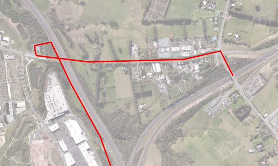 https://www.greaterauckland.org.nz/wp-content/uploads/2026/02/NW-Busway-Indicative-Design-2026-02-Northside-Dr.png
2. With the bridge in place a short connection from the busway to Northside Dr is all that’s needed to allow 12 to come in from Massey, use station, pop up busway then over Northside Dr and on to the motorway at Trig Rd – creating effectively an Upper Harbour Express service. Could then add in interim style stations at Brigham Creek (east).
This is where the $19m should have gone. Making the best out of the new station and optimising local access – foot, bike, bus.
I think the 12 and the UHEX should be separate services, as they do different things – 12 for local trips and detouring via the various suburbs like it does now, and the UHEX for going directly as part of regional trips (albeit with a few stops @offramps when budget allows). Agreed on your bridge solution though.
i agree for the Hobsonville portion, the 12 should stay the frequent route along Hobsonville Rd, maybe realigned to terminate at the Hobsonville Point wharf. Ideally there should’ve been a busway built along SH18 between Westgate and Squadron Drive by now, and a WX2 service from Hobsonville Point to the city universities to complement the WX1 like how the NX2 does the NX1.
the Greenhithe portion is a bit more complex bc of the lack of a complete interchange at Greenhithe Rd and the residential catchment being mostly well north of the Upper Harbour Motorway. Maybe the tradeoff of a slightly slower travel time via Greenhithe Rd is worth the direct service for the UHEX (or 12X?) I mean it doesn’t seem like that stretch of local roads should be congested even at peak….
Doing at Albany Hwy what was done at Te Atatu Rd interchange re. bus stops would be possible, though.
@Borrower
I think it’d initially be no stop, but eventually it’d be a pull off spot under the bridge for Tauhinu Rd and Greenhithe Rd, with stairs/ramps up to the roads above. Obviously there would be fences/cameras/barriers etc. between the buses and general traffic but it would essentially just be the bus stopping on the glorified shoulder. Although a bus only entrance/exit on each of those interchanges might end up being easier to get across the line.
The UHEX is rapid transit, so every detour takes away from the rapid part. Especially given that part of the journey is meant to be the timesaver compared to driving (as bus should go roughly the same speed as normal traffic off-peak, albeit with a few extra minutes for stops, but during peak they should be faster than normal traffic as they can use the shoulder). The whole point of having the 12 as well, is allowing the rapid transit to not have to be stuck serving local destinations/stuck in traffic.
Sure eventually there might be a busway, but this is more an interim minimum viable product (signs and paint on the shoulders to allow buses/emergency services to use it), as all the large budgets should be going to other routes instead.
Not holding my breath for the Northside Dr bridge to ever get built! Although maybe they can get Costco to pay for half of it since it’ll greatly benefit their customers …
I called into Dury and Paerata om Monday about lunchtime. A rough count of cars in the park n ride was 150 at Dury and 130 at Paerata. There was 1 Vespa at Dury but no bikes. There were a few less cars in the Wilson paid for car park at Pukekohe but the free carpark was full. The stations are good toilets bus stops and a drinking fountain but you would have to hope so given they cost a 100 million each. So the Westgate bus station looks good value. We are making real progress.
How was $19 million saved? (Cathedrals last an incredibly long time making them fantastic value for money).
It’s great, both being under budget, future proofed for both buses/light metro/whatever ends up being built along SH16 (buses won’t have the capacity), and the extra money being used to help other parts of the NW.
still wondering why the Te Reo name of Westgate station changed from Pukewhakataratara to Te Waiarohia, when Pukewhakataratara (the hill Massey sits on, the summit is I think near the Don Buck/Royal Rd roundabout) is closer to Westgate than the headwater of the Waiarohia Stream (east of Trig Rd)?