What to name the various parts of Auckland’s rapidly evolving transit scene has been a recent topic of discussion.
First was Jon Bridges’ riff on the soon-to-open City Rail Link: “our new beautiful subterranean train set deserves so much better” than the letters C, R, and L, he wrote, provoking a public outpouring of acronyms and nicknames.
Then, from Justin Hu at 1News, came a more serious look behind the scenes of Auckland Transport’s ill-fated struggles to name the new Metro rail lines.
I say ill-fated, because the result of all this work is truly terrible, unmemorable and clunky to the point of risible: E-W, O-W, and S-C. The kind of outcome only a committee could arrive at, and surely in need of quietly moving on from.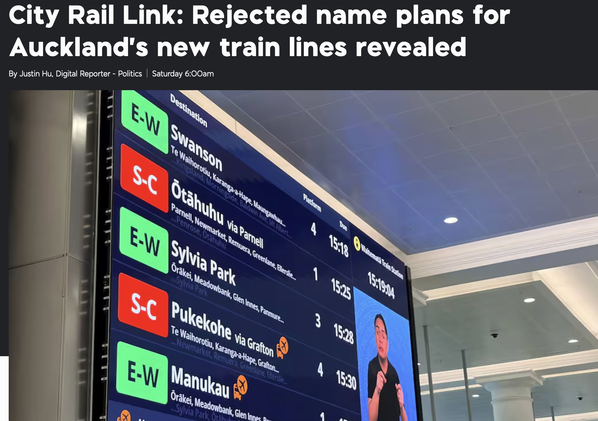
The name of the game: strategic alignment
What connects these difficult discussions – and why they haven’t led to clear and enduring naming ideas – is that they’re both disconnected from any higher strategy behind Auckland’s growing transit system. Which is understandable in the first instance (CRL popular names) and unforgivable in the second (AT’s line naming).
In executing public policy, misalignment with higher strategy is often the ultimate cause of suboptimal outcomes.
Allow me to explain.
Since its amalgamation as a Super City in 2010, Auckland has been on a very successful – indeed impressive – programme of reinventing its public transit. That this has worked as well as it has, is due to a somewhat surprising alignment between the new Council, its transport subordinate Auckland Transport, and central government (including MoT, NZTA and KiwiRail).
This hasn’t always been the case, and still isn’t in important ways – see for example the RoNS, the Harbour Crossing, and other misalignments.
Indeed, the policy misalignment between central government and the new Super City was initially so wide that in 2015, then-Mayor Len Brown and Transport Minister Simon Bridges launched a whole joint programme called the Auckland Transport Alignment Project [ATAP], to find where they could agree.
From the very first ATAP report in 2016, there’s been really good output on what was called the Strategic Public Transport Network, the highest tier of public transit (see below).
As you can see – and this is particularly relevant to our current naming issue – this strategic network has been seen from the get-go as comprising multiple modes. Three in fact: Rail, Bus, Ferry.
And it may include even more in the future, such as Light Rail.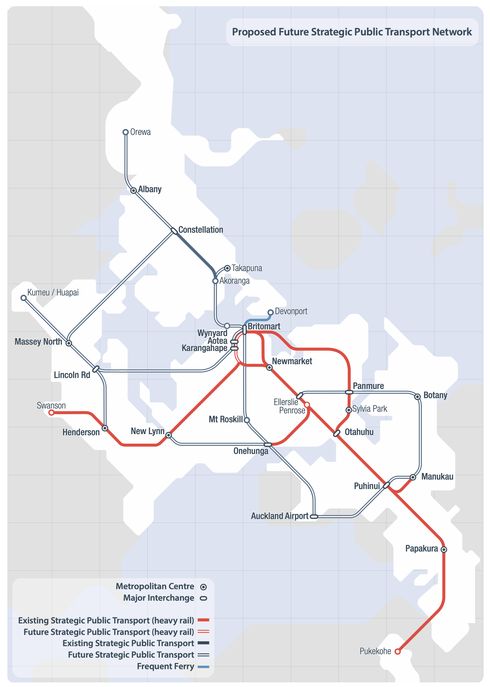
So what’s in a name?
This top tier of the PT system is the equivalent of where the motorway system sits compared to the rest of the road and street networks (which in ATAP is called The Strategic Road Network.)
The Strategic Public Transport Network sits above the important remaining bus and ferry systems. It is designed to be distinct in quality, and an interconnected whole. The map is the key: it shows the ambition to cover the whole wider city with at least one line of that top-tier system.
In cities across the world, the common descriptor for this type of top-tier urban PT network is RTN, or Rapid Transit Network. The next layer down is called the FTN, or Frequent Transit Network.
In anticipation of the CRL opening, Auckland Transport has now released a new map:
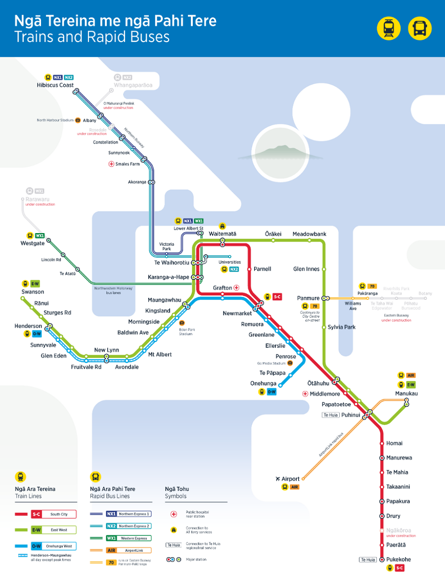
Auckland Transport’s RTN map 2026 – Apr-26
This is great: we can see the continued execution of the future system we saw in the 2016 ATAP map a decade ago. The new map is clearly trying to show show us one network made up of various modes, but doesn’t fully commit to that kaupapa.
Instead, it’s stuck in a mode-focused separation, complete with the very clunky and uninspiring title, “Trains and Rapid Buses”. So prosaic. Not selling. No rizz.
Ideally, all the lines on this map would have names from a consistent system. Instead, we have buses using a three-digit, two-letters-plus-one-number system, e.g. NX1, NX2 etc; and rail lines with hyphenated letter pairs, E-W, O-W, S-C.
The one ferry, not even shown on the map, is just called Devonport.
Now, of course everyone knows when they are on a train, a bus or a ferry. But a consistent naming approach for the lines tells you the level of service you can expect on these special RTN services.
These names could be anything – colours, letters, numbers, birds, Te Reo, English, whatever – but they should be consistent across all its constituent modes.
If it is considered super-important to still remind people of the particular mode of each part of this network, then there is the Sydney model: T1, B1, L1, F1, M1, etc.
This map shows the origin of the strategic misalignment in Auckland Transport’s naming process, as described in the 1News story. The scope of the question was clearly limited to: “What do we call these new rail lines?”, when it should have been: “How should we name all the lines of the RTN?” [something I learnt while at NZTA – control the scope: control the outcome].
This is important: a consistent naming system underlines the coherence of the whole network, aligning the growing system with its strategic intent.
Additionally – and this is perhaps the source of Jon Bridges’ plaint – the network itself also needs an expansive, clear and enhancing name.
A map of the RTN – as distinguished from the FTN – is, or should be, designed to inform and inspire potential travellers so they can see it as the citywide system it is, a coherent and connected whole. It should instantly sell the whole project to everyone who might use it.
This is the strategy all over the world: almost every city has one of these maps (a paper version is a favourite souvenir for travellers), and a catchy name – often an acronym – for its top-tier system.
And, as we have championed many times before on Greater Auckland, there is a splendid name which has been lying around unused for decades. Elegant, concise, catchy:
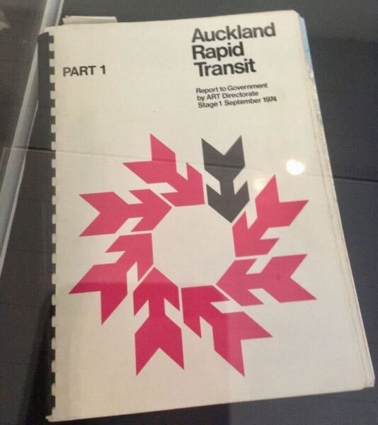
Auckland Rapid Transit or ART
This was the name for the combined rail-and-bus rapid transit plan proposed by the great former Auckland Mayor Dove-Myer Robertson in the 1960s. The great missed opportunity of Auckland’s urban past. Check out the BART/ Washington Metro-like train design:
Last week I posted the same point on Linkedin, and it proved popular with all sorts, from here and elsewhere and both sides of the aisle. ART is a broad church!
And guess what, Auckland Transport already even has an Auckland Rapid Transit Pathway. That’s right – they’re already on a pathway to ART.
Scoop! The OG report:
Greater Auckland’s work is made possible by generous donations from our readers and fans. Support our work by joining our circle of supporters here and setting up a reoccurring donation.

 Processing...
Clearly we need to revive the “ART Directorate”. Humbly i offer my services as a director…
Hear! Hear!
I 100% agree with this, Patrick. The top tier of public transport should be marketed as a single entity, hopefully with a catchy Auckland-relevant name that people will willingly adopt and proselytise, and even take pride in. It’s a golden marketing opportunity gone completely begging.
I mean you have to be careful with it as there’s big chunks of the city not served by this and insane time-frames for doing anything about it.
The whole point is to show what there is, and what we’re working towards.
From absolutely nothing at the start of this century to that map above is a huge achievement.
Plenty would have told you, certainly did smugly shout in fact, that what we have now would NEVER happen. I see no reason to not confidently publicise this.
If a Transit fairy godmother had appeared before me in 2000 and said would you like this RTN for AKL in 2026, new network of electric trains with a new city underground route, E-buses on busways, integrated ticketing, all supported by the also ever improving FTN below it?
Would I have unhesitatingly grabbed it with all paws? Hell yeah!
That’s a poor reason not to market what we have. The chances of more being built will be closely related to how well what we have is used.
What about CART (Combined Auckland Rapid Transit)
“Let’s hit the cart”
I’m also partial to the Jaffa Dispenser
Howabout :Concentrated Rail Legacy? As an attempt to apologise for destroying our tramways in the 1940s. As a promise to the future that we will prioritise rail corridors for transport projects? As a threat to fossil fuel dominated private metal box on wheels system that we currently suffer from in Taamaki?
Semantics are not what matters here, what matters is time. We have monekeyed around building motorways since the 1950s and it has destroyed any chance of becoming a true super city.
When we have our ten to twenty storey apartments as a dominant feature around well designed train stations, then perhaps the people will finally arrive in our great town…to fulfill its promise of becoming a CITY!
Important note: a city must contain five million people to move out of the the “big town” classification.
Also important to note we are the size of Los Angeles, and full of ghost houses, land banked for eternity. BUILD APARTMENTS NOW or we will not have the people to fill our newly restorated Saint James, and the soon to be respectfully restored Building One in Carrington. Art for Arts Sake and Apartments for a livin’ thing, which is a terrible thing to lose
bah humbug
” “Trains and Rapid Buses”. So prosaic. Not selling. No rizz.”
Err, you’ve stuck “Selling” next to rizz, so I assume you’re wanting to use the Gen Alpha interpretation?? Which is the opposite of the conventional one.
So it should be , Selling, No Rizz. … “Not selling” is a double negative to the current generation of 12 year olds…
Yeah, ok, but no, not intending “selling” to read as shorthand for selling out, just in its plain meaning as not selling the service. But fair enough, is a possible reading cos I try my hand with “rizz”.
Busted.
Frequent Auckland Rapid Transit (FART)?
Can be expanded to Wider Auckland Rapid Transit (WART)
Could also be called Combined Rapid Auckland Passenger Services (CRAPS)
If they built LRT we could have the Old FART and the New FART.
I think having different naming schemes for different modes is good. Otherwise it might be hard to understand why you have to leave Waitemata and walk through a shopping mall to catch another part of the rapid transit network.
NX and WX are well-established brands by now and I don’t think we should get rid of these. And honestly, East-West and South-City are growing on me, they are simple and descriptive. Other systems only use numbers and you have to figure out which train you have to take and then you need to say something like ‘take the T4 to Papatoetoe’ anyway, which is what we have with other buses. At least South-City tells you were it goes.
John, that you say “NX and WX are well-established brands” and “East-West and South-City are growing on me” is why it is so important to establish appropriate, consistent and evocative naming with a long term (dear I say strategic) view. For regular users of a service it actually doesn’t matter what it’s called they will use the bits they need regardless. It is the occasional user and tourist who really benefits from super clarity in naming. If English is your 2nd language, you are from the northern hemisphere and the sun is in the wrong quadrant of the sky to start with a line called S-C is not as useful or recognisable as the RED line.
I’m for “ART” and colour coded lines and line names – there’s a consistency there. Blue to be retained of the ferry, of course.
And also think they can be confusion for newer users that the East West actually starts/ends in the South of Auckland.
If you want to go non-descriptive, numbers are far better than colors. Colors are a pretty limited set especially if you want some consistency across modes. A transport map with every colour-coded line in the respective colour will also be quickly very busy. Accessibility for colourblind people might also be an issue.
Regarding tourists or new users: As said in comments to another post, you have to get used to a new naming convention regardless. All maps that you look at will have South towards the bottom (exceptions may apply), so there is no need to navigate using the sun. As soon as you want to go somewhere local that is not close to a train station (e.g. take a connector bus from the busway), you will have to learn numbers anyway.
South-City is daft, because it suggests the East-West doesn’t go to the city.
The logo cover of that report from 1974 immediately reminded me of the Commonwealth Games logo of the same year.
ART is a word! That’s why it works folks. All those acronyms are nothing burgers.
And we have been incredibly lucky to live in a country with few humans all our lives. WE DO NOT NEED FIVE MILLION PEOPLE HERE! Sorry no city is needed. Kennedy Warne (geographer) says Aotearoa/NZ was the Amazon Basin of the Pacific. The lungs and the ecosystem – the incredibly rich and _unique_ flora and fauna. The Auckland water man was on the radio last week saying everyone accepts climate change is real now. Well if you still want a 5mill city in NZ you are in fairyland as built by Walt Disney chumming up with the Minister for Bye Bye Freddy the Frog. Not here and now dealing with climate burning and flooding and a future of more of the same.
It would be nice to see engagement with the actual arguments (given in the 1News argument) that AT honchos made for using the E-W branding and turning down the T(number) branding
“A spokesperson for AT said: “The directional line names met customer needs better than other options, including the bird names. This was the key reason for the decision.”
This is not an argument, it is simply a claim.
Anyway, their argument, such as it is, did not even convince their own internal group:
“By September, internal presentations acknowledged the ELT “wasn’t aligned on this decision.” One executive noted the timeline was “not realistic” for the bird names and suggested revisiting them “at a point in the future”.”
Bird names would make the lines so unique. You could maybe even work the birdsong in there for platform announcements inside the train, or on the platforms (though that could confuse actual birdlife), or advertising for events that take place somewhere on the line. Maybe also wraps for the train carriages by local artists to really make them stand out.
Slightly (less) Mediocre Auckland Rapid Transit (SMART)
That hurts.
Beautiful Rapid Auckland Transit – Bringing back the BRAT summer
‘Take the EW, OW or SC, your ticket to a BRAT summer.’
The ART-eries of the city?
Something bilingual would be good, so long as it’s less clunky than ‘Motu Move’.
What advice did AT get from manawhenua?
I do not understand why that isn’t just MOTU, as in gets you around the Motu, ie everywhere. Obviously appropriate for a national ticketing product. The “Move” is entirely redundant, is too long, over-explaining, un poetic. Lacks snap.
It seems the same sort of pedantry or literalism that bedevilled this line naming process dominated the National Ticketing decision.
I was on the Waka Kotahi board at the time and it never came to us to even add our thoughts to that outcome, it just arrived, from some project group, as a fait accompli.
It seems these decisions are being made poorly through odd processes.
Interesting. Did the Board even strategically tell management to be cautious with Māori words as the Ministers were demanding, or did the managers perhaps just pick it up by osmosis in the Thorndon bubble soup?
Probably getting ahead of the Facebook warriors who would demand there be an English translation, after calling the use of Motu “woke”.
Which leaders do we work on?
There are only 3 AT Metro rail line so keep it simple for everybody including tourists understand.
‘S-C’ becomes the red line with EMU front and side destination screens with a red back ground with white lettering of the destination like ‘Pukekohe’, ‘Watimata’ and ‘Newmarket’
‘E-W’ becomes the green line with EMU front and side destination screens with a green back ground with white lettering of the destination like ‘Swanson’ or ‘Manakau’
‘O-W’ becomes the blue line with EMU front and side destination screens with a blue back ground with white lettering of the destination like ‘Onehunga’, ‘Mungawhau’ or ‘Henderson’
There is no need to ‘S-C’, ‘E-W’ and ‘O-W’ only the line colour on station arrival displays and and printed material.
Same applies to branded bus route’s like the ‘Airportlink’ with the bus its front and side destination screens with a orange back ground with white lettering of the destination like ‘Airport’ and ‘Manukau’.
Keep it simple like travelling from city centre to airport like saying ‘take the red train service to Puhinui and the orange bus to the airport.’
Agree, colours work best. All the train lines have a colour anyway, why have a separate name too. We will never run out of colours in Auckland.
Agree. Red line, green line, blue line… easy, obvious and memorable.
I like the idea of using those colours on the front and side screens of the trains, so you know where the train is going even if you didn’t see the front of it.
It’s fine that the NX and WX are called something different. It’s actually helpful to know that it’s a bus not a train. Maybe one year when we have light rail and a metro, we can do something different. For now though, keep it simple.
Which is not to say calling the whole thing ART isn’t also a good idea. It’s much better than Rapid Transit Network and Frequent Transit Network. What do those even mean? The trains aren’t exactly rapid, or, much of the time, frequent, by AT’s own definition (nor are some of the so-called frequent buses). And it’s not as if rapid and frequent are mutually exclusive.
Agree on train line names using colours, and ART for the whole network.
I would leave the “X” on the busways just to reinforce their different status from regular buses. Eastern Busway should therefore be “EX”
It goes South East doesn’t it?
Services the east. Besides, single letter + X, for consistency.
And “SEX” might be deceiving..
Might increase patronage…
While they don’t have the best track record, AT are experienced at running trains. As long as the services don’t arrive prematurely, I think it would be a hit
For the lines themselves, the only acceptable and sustainable solution is a portmanteau of the first sylable of the start of the line and the second syllable of the of the end of the line. These names could be updated as even further stations were added (ideally without notice).
Therefore, ‘EW’ becomes a much easier to understand ‘Swan-kau’, ‘OW’ becomes ‘Hend-hunga’; ‘SC’ becomes ‘Puke-T’ and so on.
Do it once, do it right.
There is some confusion between lines and services.
Northern Busway carries NX1 & NX2 as well as a number of FTN and other services.
Eastern Busway also carries a mix of services that do not include an EX1.
WX1 doesn’t even have a Busway yet.
Likewise the NIL and NIMT carry an assortment of rail services, freight and passenger.
So be clear what we are trying to find names for.
We are trying to find names for the network of rapid transit services. Train and bus services that aren’t rapid and aren’t planned to be rapid don’t count, even if they share some of the infrastructure.
Yeah I don’t see how I could have been more explicit in the post. This is about the “Top Tier” of PT services.
Interesting that AT have a very good naming system for differentiating between the Frequent Network bus services and the local collector ones:
The FTN use two Digits and the Collectors three.
This does suggest that single digits could be used for the RTN. And they sort of are, at least for buses, but for some reason AT insists on adding directionally derived letters as well, and seems unable to get away from different systems for different modes.
Obviously I think this should change- basically that’s the whole post.
‘Trains and Rapid Buses’ is an odd choice…I’m wondering if there is a reason why they have not included the trains as ‘rapid’, such as possibly their average speeds are too low to meet the ‘rapid’ definition.
Or maybe the mapmaker had worked to a tight deadline to finalise the map and they were getting pressure from different people to name it ‘trains and buses’ or ‘rapid buses and trains’…so they just quickly typed in something in between and hit Submit.
I think its just to differentiate the busway services from regular buses?
I imagine this is exactly it.
I quite like the concept of using sports stars just to be different. The Chris Harris line and the Sean Fitzpatrick line. Take the Fitzy to K Road and change to the Harry. To be honest that would be better than E-W.
I like the idea because you seem like an ideas man! It would be like catching the Paekakariki Express (presumably a bumpier ride though)!
Giving human names to lines that are commemorative instead of just prosaic names is probably a luxury for cities blessed with many different mass transit routes.
Good idea.
ps I’m glad you seem to have referenced a 10cc song “Art for Art’s Sake”.
…money for God’s sake”
Anyone has read the Murderbot series by Marsha Wells (recommend) will have a chuckle at a transport network named ART.
Agree that themes and stories that we tell ourselves have an impact on our behaviour.
Really looking forward to seeing the stations on the inside, and how it changes travel patterns.
Given an acronym, people will come up with their own ideas of what it stands for. What’s wrong with WEEEE! WOOOO! and SOC!
Taipei city’s world class transport system uses colours to name the routes. Green, Red, Brown, Blue etc. So using it is a breeze. The map shows the colours, and you just follow the signs with that colour. You don’t need to read, or understand Chinese or even English
How about “MetroART” or “ARTMetro” – then AT can add lots of murals and artwork to the stations & bus stops as well. It could become a marketing tool and tourist interest.
I’m all for the Sydney naming convention or similar.
Tn, BXn (or XBn), Fn, (& Bn for standard buses), where n = 1 to j services.
Imo the Sydney based approach T1, T2 & T3 would make the most sense.
For the buses I dont mind them retaining NX1, WX1 etc. But the airport bus should at least be called SX1, and when the Eastern busway is completed it should be called EX1.
For ferries, just F1, F2 etc would be fine.
It makes it so much more simplified.
That way when light rail finally comes to Auckland it can have an L designation.