On leg five of our journey we meandered from Zaragoza to San Sebastian (Donostia in the local lingo, which I respect even if I revert to San Sebastian for the remainder of this post). For this particular leg we took the bus (ww.alsa.es), mainly because it was about the same travel-time as the train (3.5 hours) and cost only half the price. Plus the bus left at a more convenient time for us than the train. The route we took is illustrated below.

The bus left at 8.30 and dropped us in San Sebastian 3.5 hours later, pretty much right on-time. I was pleasantly surprised to find that there was free wifi on the bus, which appears to be a standard feature on Elsa long-distance bus services in Spain. Worth remembering, because free wifi is honestly a god-send for travelers who may not have a local mobile data connection. And it’s definitely an advantage over BlaBlaCar ride-share, which we used for our last leg (you can read about here).
The first half of the journey traversed relatively flat dry (albeit fertile) land in the Ebro river valley. In terms of history, I understand the Pamplona marks the northern-most point in the Moors occupation of Spain, which began with an invasion from North Africa circa 700AD. In the following map, you can see just how much of modern Spain was initially occupied, and also how long it took for Christian forces to re-conquer the territory (source). Even 600 years later, there was still a sizable area of Moor occupied territory.

From Pamplona to San Sebastian, the road took us into greener and more mountainous terrain. Indeed, it was these mountains that protected northern Spain from the invasion. They create a natural barrier and are partly the reason why the rail network in this part of Spain is relatively indirect / convoluted.
All this, however, is set to change over the coming years; the Basque region is in the process of developing their own high speed rail network linking Bilbao, Vitoria-Gasteiz, and San Sebastian, as illustrated below.

More details on the project, including origins and financing, are available here. There’s a couple of interesting aspects of this high-speed rail network that are worth dwelling on. The first is that it connects to a wider high-speed rail network in two places: Madrid to the south and Bordeaux to the north.
These two connections change the optimal route for trains travelling between France and destinations in Spain to the south. As you can see in the image below, the optimal route between Paris and Madrid is currently via Zaragoza to the east, whereas the new HSR network may make it more efficient to connect via Vitoria-Gaistez to the east. Incidentally, travelling by train from Paris to Madrid takes 12 hours in total, of which the section from Paris to Bordeaux only takes 3 hours while the section from Bordeaux to Madrid currently takes 9 hours. The ability for the Basque HSR network to reduce these travel-times is the main reason why it has attracted EU funding.

The second interesting thing about the Basque HSR network is that it looks like there’s a couple of branches to San Sebastian and Irun. Now, as Jarrett Walker has written about here, branches dissipate frequency and complicate network design. My hunch is that these cities do not receive direct HSR service, but must instead use local services on their respective branches to connect to a HSR station somewhere further down the line, perhaps Vitoria-Gaistez.
Nonetheless, the development of this network is rather exciting, and it’d be interesting to see how it turns out, and the impact it has on regional connectivity, which incidentally is rather poor at the present time.
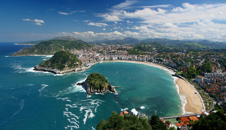
In terms of San Sebastian itself, well it’s simply stunning and perhaps the most beautiful city I’ve ever experienced. The reason I say this is because it is beautiful in both a natural and a built sense; the harbour, hills, beaches, and buildings all combine to create an extremely aesthetic experience. The image below gives you a sense for the wider area (source).
San Sebastian occupies an extremely strategic location right on the Spanish / French border. It was also a decent harbour and relatively defensible. Hence it was one of the first locations occupied by Napoleon’s armies, and it was subsequently razed to the ground while being “liberated” by the British and Spanish forces. So circa 1815 the entire town effectively needed to be re-built. The “old town” was rebuilt more or less on the old street grid, with a few changes here and there (slightly wider pedestrian streets etc).
Then, in 1863, the town won the right to demolish its fortifications and expand. Wiki puts it thusly:
In 1863, the defensive walls of the town were demolished (their remains are visible in the underground car-park at the Boulevard) and an expansion of the town began in an attempt to escape the military function it had held before.[14] Works were appointed to Jose Goicoa and Ramon Cortazar, who modeled the new city according to an orthogonal shape much in an neoclassical Parisian style, and the former designed elegant buildings, like the Miramar Palace, or the Concha Promenade.[11]:145–146 The city was chosen by the Spanish monarchy to spend the summer following the French example of the nearBiarritz. Subsequently the Spanish nobility and the diplomatic corps opened residences in the summer capital. As the “wave baths” at La Concha conflicted with shipbuilding activity, shipyards relocated to Pasaia, a near bay formerly part of San Sebastián.
Basically, the expansion of San Sebastian catalysed a re-focusing of the town onto recreational activities, with industrial activities relocated to surrounding environs and/or even, in the case of port operations, nearby towns. Moreover, the resulting street network and architectural style really is rather lovely. The connected nature of San Sebastian’s street network is evident in the following image, which is taken from Google Maps.

One of the interesting things about San Sebastian is its wide deployment of one-way streets. Now I know many urban designers gag at the thought of one-way streets, and partly for good reason: In the Auckland context, Nelson and Hobson Streets are horrendous place-destroying one-way monsters. In San Sebastian, however, the outcome is usually (not always) rather different. More specifically, in San Sebastian the negative impacts of one-way streets is mitigated to a large degree by urban design treatments. This includes wide footpaths, many pedestrian only streets, and long / frequent pedestrian phases at signalised intersections.
This reminded me of a post I wrote a while back about how it may be possible to “upgrade” Nelson and Hobson Street while retaining the one-way function. In this post I describe how an urban boulevard design treatment on Nelson and Hobson could seek to split the through and local traffic functions, thereby creating low speed access lanes adjacent to buildings on either side of the street. The speed of vehicles travelling adjacent to the footpath would be considerably reduced. You might even implement two speed limits: 30km/hr on the access lanes and 50km/hr on the through lanes.
Moreover, and perhaps more importantly, such a configuration would free up space for wider footpaths and all manner of other amenities.
I don’t know what the status of the planned two-waying of Nelson and Hobson Streets, but it may be worth considering an option that retains the one-way function of Nelson and Hobson, while transforming them nonetheless into much nicer places to be. If anyone out there is interested in seeing how one-way streets might work in a sensitive urban environment, then I’d recommend visiting San Sebastia.
At the present time I’m actually sitting further east in Gijon, Asturias, i.e. I’m one step behind in documenting our travels. So it’s probably an appropriate time to for me to finish this post, have a glass of rioja, and start thinking about the next post. Adios.

 Processing...
How I love the Basque Country, and especially the cities; compact and therefore nestled right in the lovely countryside. Otherwise it’s so like NZ; green pasture, hills, sea, even rugby fields! Like southwestern France this is a rugby land…. just so much more urbane and with great food, and urban form and transport. The trains are really good, even if Renfe’s website isn’t always so clear.
On Spanish cities I strongly recommend David Gilmour’s 1992 classic: Cities of Spain.
Stumbled across San Sebastian by accident on my European travels a few years back. Very relaxing break from the bustle and size of the big cities. Beautiful scenery and walks, nice beaches, and compact city. The locals were some of the most friendly and welcoming I have met in my travels. Can’t recommend this city enough.
The new high-speed rail connection calls to mind a much earlier cross-border rail connection that I stumbled upon while vacationing in SW France in the late 90s. I was fascinated by what seemed to be an abandonned electrified railway south of Pau (I can’t resist exploring old railways) and followed south it up the Aspe valley. towards Spain. Walked some of it the following day through tunnels and across spectacular stone-arch bridges in the Pyranees. Subsequent research showed it to be a route from Pau to Canfranc via the Somport tunnel.completed in 1928 and closed in 1970 following a serious accident that resulted in a runaway train demolishing a bridge. Take a look at Canfranc station on the Spanish side – French standard gauge track one side and Spanish broad gauge the other.
https://impossibleliving.files.wordpress.com/2010/12/canfranc_station_spain.jpg
https://en.wikipedia.org/wiki/Canfranc_International_Railway_Station
https://en.wikipedia.org/wiki/Pau%E2%80%93Canfranc_railway
MFD, that first link sure is a surreal sight.
Yes, surreal describes it. Once the largest station in Europe, 241m of amazing architecture lording it over a mountain village of 1000 inhabitants.
The good news is that SNCF (the French national rail company) intends reopening the tunnel and the rail connection to Spain in 2020. Might have to take the trip once it is open. There are few better places than SW France in the summer.
What a magical place. What a phenomenal waste of a railway.
At least the Swiss don’t trash their railways like this.
…but the Swiss don’t have crocodiles on their railways any more.
The Spanish still run two trains a day from Zaragoza to Canfranc.
Yes, it’s the French side that has been abandoned, and sadly the mighty Somport Tunnel.
But one cannot but help feel that a majestic station like Canfranc should see more activity that 2 trains a day, and it can only do this if the international through-route opened again. One can but hope.
I’m sure there are a few preserved crocs tucked away in depots and museums, and occasionally you see them out.
http://www.martynbane.co.uk/2003Trips/Brienzetc/oct042003.htm