One of the most exciting projects in the City East West Transport Study (CEWT) is the addition of a busway through the central section of Wellesley St – which is defined as between Kitchener St and Albert St.
The central section of Wellesley Street near the Queen Street core contains a number of key cultural facilities including the Civic and St James Theatres, Auckland Art Gallery, Auckland Central City Library and also intersects with the Elliot Street shared space and connections through to Aotea Square. The importance of providing a quality environment for pedestrians and place making within the area cannot be overstated.
While the study has confirmed that the linear park project is best located on Victoria Street and there is a need for a bus corridor along Wellesley Street, there remain considerable opportunities to also obtain the desired improvements to pedestrian and amenity provisions within Wellesley Street central.
In particular, there may be an opportunity to close the central section of Wellesley Street (between Kitchener and Albert Streets) to general traffic, which would be rerouted for example around Mayoral Drive. This would enable the carriageway width to be reduced and reallocated to the pedestrian realm and also reduce the feeling of vehicle dominance within this area. This traffic closure would have additional benefits in allowing greater signal optimisation for buses and pedestrians at the Wellesley Street / Queen Street intersection, and may also unlock opportunities for improvements on adjacent blocks of Queen Street through reduced traffic and the reduction of bus stops.
For that central section the busway would be a full four lanes wide, two lanes for movement and two lanes for buses stopping. When you include the bus stops, parking and loading zones the carriageway is actually about six lanes wide so this proposal actually represents it being narrowed down. That in turn allows for the footpaths to be extended which is something likely to be needed considering the number of people that will be moving through the area thanks to the people fountains the buses will be.

The image below highlights the benefits to pedestrians showing that they go from having 30% of the space in the corridor now to 48% with a bus only road in place.

And here’s the proposed layout vs what we have now. While the diagrams are just listed as indicative, I suspect that in reality the vehicle lanes would be closer to the northern side which would allow much more space on the south which gets more sun and out the front of the Civic Theatre.

In addition to the extra space on Wellesley St, the changes to the bus routes and the inability of cars to turn off Queen St would mean the carriageway on that wide section of Queen St could also be narrowed. In effect it could leave us with quite a large footpath build out of the Civic corner.
But why is a busway even needed?
Currently around 24,000 people enter the CBD by bus during the morning peak however by 2041 it’s expected that number could be up to 45,000 people while vehicle volumes are at best flat. Like we’ve seen over the last decade, all the transport growth that will occur in the CBD will happen through public transport or active modes. Even with higher capacity buses it still means we’ll need a lot more of them on the roads delivering people to and through the city centre. It’s this reason that the City Centre Future Access Study determined that a mix of both the City Rail Link and improvements to surface buses would be the best solution.
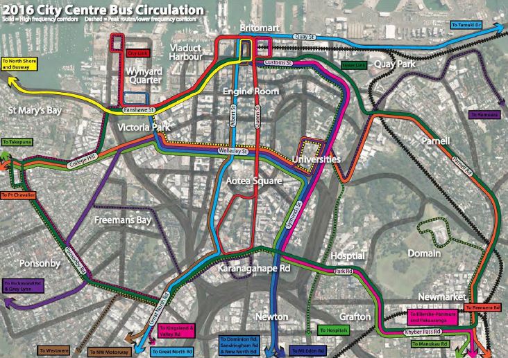
Currently buses to the CBD use a wide variety of routes with the main corridors being Fanshawe St, Albert St and Symonds St. There are a number of buses that also terminate or travel through the Civic area.
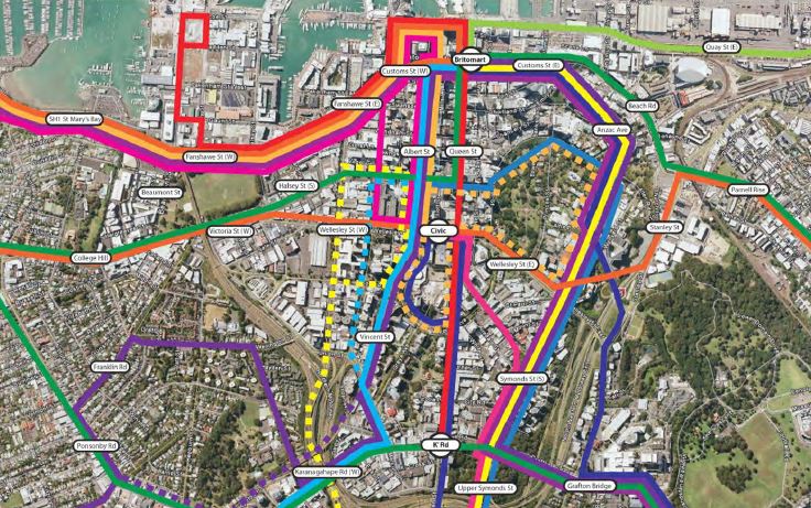
The New Bus Network is seeing routes overhauled and while we won’t see the official plans for the City Centre till the central are consultation (which is expected next year), one of the features of the network is that routes will be concentrated on to a few key routes. The current proposal below sees two North-South routes (Albert St and Symonds St) and two East-West routes (Fanshawe/Customs and Wellesley St. The Wellesley St corridor is home to a number of all-day frequent routes including but not limited to buses from:
- Dominion Rd
- Sandringham Rd
- New North Rd
- Remuera Rd
- Manukau Rd
- Pt Chev via Westmere and Herne Bay
- Grey Lynn and Ponsonby
A quick calculation suggests that could represent over 100 buses an hour before taking into account the non frequent routes and the peak only routes that would also pass through the corridor. That would likely to be too much for single bus lanes to handle without getting horribly clogged up with a wall of buses.
So why not use either Victoria St or Mayoral Dr for the buses
As many people will know and as the first map shows, buses currently use both Wellesley and Victoria St for East-West movements and some may ask why we shouldn’t just keep doing that. There are a number of reasons but a couple of key ones are that it enables customers to transfer much easier between services but it also enable other city centre improvements to happen. In particular the plan is to have a linear park on Victoria St connecting Albert Park with Victoria Park.

As the report notes a number of people have questioned whether the Linear park should be on Wellesley instead (with presumably buses on Victoria St). The report (page 234) highlights the results of some of the significant analysis that is said to have gone in to confirming that Victoria St is the best location. The other east-west street in the middle of the CBD is Mayoral Dr. Again it would require bus routes to be longer and therefore higher operational costs but it would also move the buses (which will be moving many more people to the city than cars will) further away from the centre of town where the majority of people will be living or working. The table below shows the expected CBD population and employment densities in 2041 showing the concentration north of Wellesley St.

In my view the Wellesley St busway would be a welcome addition to the city centre and along with the other improvements to the area represent a huge step forward for the CBD.

 Processing...
The linear park on Victoria makes total sense, sort of linking Victoria Park with Albert Park. My concern is that Wellesley St doesnt work for PT right now, let alone in the future with more buses. You only need to look at it in the PM peak with massive queues of westbound buses and not enough bus stop space on the southern side of Wellesley around the Civic. Ive seen a queue of 10 or more buses trying to get out around from AUT to head west. The double Barnes dance at Queen St doesnt help much either because the crossing next to Elliot st is linked directly to the Barnes Dance, so buses still get stuck after they pass Queen St. It should work ok in the AM and during the day, but the PM peak it wont really work at all. But they dont really have other options as Mayoral isn’t that practical.
One of the outcomes is like a removal of the Barnes dance from the Queen/Wellesley St intersection. This would be possible as only two vehicle movements would exist so it would be much simpler
Ditching the barnes dance? Handing space over to parking buses?
It seems to me that we are now doing for buses what we once did for cars… Eventually we’ll have buses ruling our city in the way that cars now do. I’m not sure that’s a positive outcome…
We need better plans than this.
It’s handing back space to pedestrians, about two lanes worth on Wellesley St and on Queen St outside the Civic. Also it will be a bus stop, not a bus stop, not a bit terminating point like now
Tim, I know where you’re coming from but remember without the buses many of those pedestrians wouldn’t be there at all. We cannot just wish them away, they are the source of the people. It seems to me that with this plan there will be able to be much less loitering by buses, much less delay on road without other traffic, and much less delay at the Queen St intersection for everyone by running concurrent phases. And as Matt points out above, not only much much more pavement on both Wellesley and Queen, but also narrower carriageways to cross. All wins for pedestrians.
Yes buses are high and a visual barrier, and can be fumey and noisy. The answer to the former is to ban advertising wraps, and the later is to get much much stricter about bus quality and technology.
And another answer to both is to have efficient running patterns without lots of built in-slack necessary to make for unpredictable route length because of the absence of proper priority for the buses on our streets.
This and the CRL as soon as are the best answer I have seen to these issues, but I’m interested in any other suggestions.
We need a plan to quiet and electrify Auckland’s buses. If we don’t start doing it now, while the technology is here, we’ll end up with some pretty perverse outcomes.
Otherwise, it looks great!
If we combined this with a mandate that all commuter busses heading into the city centre must be a hybrid electric/diesel bus then we could combat the noise, pollution from standing start acceleration while still making them realistically useable for the long runs and less cost prohibitive than a fully electric bus. Remember those green hybrid Link buses, it seems like we have gone backwards since them.
‘Wellesley St doesnt work for PT right now,’ That’s the point isn’t it? The buses there are stuck in traffic, they need the cars out of the road.
‘The double Barnes dance at Queen St doesnt help’ Wouldn’t it be changed to Concurrent Crossing under this set up? No buses are turning into or out of Queen, and likewise no general traffic is turning into Wellesley so pedestrian cycles could very safely and efficiently run, NY-Style, with the traffic flow. Great advantage of no turning at Queen St intersections, everyone gets sped through with less delay. [no matter how fond we are of the Barnes Dances!]
I see buses turning into Queen St regularly from Wellesley
Now is not the future. We are discussing the new network plan, ie not now.
They need to build it now. Already there’s a wall of buses back from the Queen St intersection!
How does the Wellesley Street Busway interlink with Symonds Street?
That’s a whole other post and a bit of a saga.
If you could post that info up, that would be good. I’d like to know how the busway is going to connect to Symonds Street and when.
When does construction of this busway begin and when does construction of the linear park begin?
It can’t happen soon enough! Like the other plans for the CBD presented here recently, this is great. It needs to happen sooner rather than later, before a slowdown before the 2016 election, inertia or some other petty problem take their toll. Let’s get it done AT and AC!
I’m not convinced. Too many buses running through what should be a pedestrian ruled space.
Run the buses up Wellesley or along Mayoral Drive. Mayoral is already a virtual motorway; why not make use of it, rather than further committing parts of our city to remain dull and grey?
You’d need a better excuse than operational costs, as I find it hard to see these stacking up with careful planning anyway. We need to get all large vehicles out of the heart of the city – putting a giant bus terminal on one of the busiest pedestrian intersections is counterproductive to making Auckland a better place for humans.
‘Run the buses up Wellesley’ Er Tim? That’s the plan. Maybe read the post again.
I trimmed that post extensively, so as not to rant for too long. Most of those routes seem to cross East-West in order to feed the Universities.
If University buses ran Symonds Street to Britomart, there would be less need to cross town.
Is this a stop-gap design until the CRL is complete, or is this a design that considers how the CRL would contribute?
There simply isn’t the capacity on the streets to send all buses through Britomart
There will still be lots of buses on Symonds St too. Look at the map. Buses are most definitely needed now, ie pre-CRL, but will still be needed post CRL too, but just not an insane and unworkable number. The CRL will carry huge loads of people and many who started their journeys on buses. And without it the city would be nothing but gridlocked buses. Post CRL many more bus runs that currently come into the city will terminate or rather recycle at integrated train transfer stations like Panmure, Manukau City, Otahuhu.
Even with the CRL we will need a lot more buses to the CBD than we have today and more people will arrive via bus then train (according to the modeling)
Matt my understanding is that that modelling is twisted by the fact that it is set up on the assumption that people don’t transfer. Yet we are already seeing plenty of transferring where ever it is a clear advantage to do so. Like now at Panmure [even though there are yet to be new trains with higher frequencies, or integrated fares, or even bus lanes to the station yet!]
I am confident that once we get these details right then the traffic model will be found to be wrong, again. I don’t think that post CRL the city will need ‘a lot more’ buses. Or if it does then someones doing something wrong. But certainly there will still be a need for buses in the city for sure.
The big winner for people like me in the isthmus is the one seat ride to Wynyard using the E/W pattern across Wellesley.
Tim, this wouldn’t be a terminal. A terminal is where bus routes end, where the buses stop, park, layover etc. This looks to be a simple stop and go arrangement between Wynyard and the university.
Why not Mayoral? Because people aren’t going to mayoral drive! This puts the stops right where people are travelling to and from, including the future Aotea station. The thing I like is I would be able to catch the train to Aotea then hop on the bus down to victoria park and Wynyard one way, or up the hill to the uni and Symonds street the other way.
Tim, this is the future vision. May or may not happen in that form, but that is the plan. Nothing entirely wrong with the plan. People want to GET TO the centre of the city, so you need bus stops in the middle there, no far off in the fringe.
Patrick, There isnt that many cars using that section of Wellesley St. Most of the trouble is caused by too many buses trying to stop in a small space. Making Wellesley bus only doesn’t fix this problem at all. You will still have the problem. A concurrent crossing phasing would be great, and would reduce that issue. Not sure if it would fly though. Compromsing pedestrian amenity for efficient movement of vehicles. Tut tut, now you sound like an dirty traffic engineer.
I don’t see any compromise of pedestrian amenity here. Pedestrians crossing the new narrower carriageway would almost certainly not even have to pause for the next phase if their aim is to go diagonally. And with no turning traffic anywhere there would always be one of the streets open for pedestrian movement at all times; you’d just go in the open direction first. I reckon it would be better for walkers. In fact this is a clear step towards turning Queen into a Transit Mall, with nothing but the City Link on Queen, so pedestrians all but ruling Queen St, like Bourke St in Melbourne.
Complicated traffic light phasing should be minimised in central areas priorised for pedestrian amenity.
For example, in the central activities district of Melbourne (Hoddle grid) most intersections have two part cycles of about 80-90 seconds, composed of, for each direction, 20 seconds of green man, 20 seconds of flashing red man, and 45 seconds of red man. There are no turning arrows for vehicles. Right turns are hook turns, traffic turning left across pedestrians waits for them as is right and a proper in this sort of area.
Compare Sydney where you might have 10 seconds of green man in a cycle of 120 seconds. It took me a while to realise why walking around inner Melbourne was so easy and pleasant compared with Sydney.
Yup and this proposal with Concurrent crossing would be simplicity itself.
I’m just not convinced it’s the best future vision. Once I started imagining you were talking about cars and not buses, I can really see that the arguments are exactly the same. Had it been 50-60 years ago, the same people advocating this solution now would have been advocating for the car-centric design we have ended up today.
“People want to get to the central city”
“It’s more efficient”
Sure, build more roads into the CBD!
It isn’t creating a better space if we’re just replacing cars with buses and adding more people. It still means busy, clogged streets. There will still be congestion and the hazards associated with large vehicles.
Mayoral drive is not far from the centre. It runs alongside where the Aotea Station of the CRL is intended to be built, allowing for simple transfers. It could easily feed a sheltered walkway to Aotea Square or Wellesley Street, and these places would be dominated by pedestrians.
We know development will come from pedestrian traffic, not buses. Stopping 50m away will not be a problem.
This is a good interim solution until we have the CRL, and transfers become a reasonable option. But transforming the whole street to cater for buses for the next 30 years could be a big mistake.
You do get the bit about doubling the ped space right? And you do understand that one bus takes up a hell of a lot less ‘clogged street’ than 50 cars, right? Not to mention where to park those things.
No it is not like a streets full of cars to shift anything like an equivalent number of people.
True it isn’t as pleasant, fast, clean, or nearly as space efficient as an underground rail line…. take that thought to that nice Mr Key, and his not nearly so nice friends.
The obvious question to my mind is what happens at the Symonds/ Wellesley/ St Pauls intersection which is already a major pedestrian thorough fare with limited space. There doesnt seem to be enough room to filter the proposed frequency of buses around from Symonds down Wellesley without completely undermining the intersection. Its already difficult enough for pedestrians in the area an I imagine there will be a continuation of the expansion of student accommodation in that area which could further complicate things. How would a route down Wakefield/ Mayoral before rejoining with wellesley fare?
A route down Wakefield St would largely skip Auckland Uni, and require buses to use Mayoral which that plan had identified as a traffic street. Better to leave that for traffic I think.
I sometimes use the east-bound Outer Link to get to work in the morning. At the moment an otherwise fairly efficient trip is marred by waits of what can be up to a couple of minutes at the Wellesley / Queen St intersection. East-West traffic appears to have a much lower priority than north-south traffic, and the situation is made worse by an excessive number of traffic phases. At the moment there is: east-bound phase, west-bound phase, pedestrian phase (long, because of the size of the intersection that has to be crossed), north-south non-turning traffic, north-south turning traffic, second long pedestrian phase. Some mornings the east bound phase can get shortened to the point where only 2 or 3 cars have time to get across. With the busway proposal, you’d be able to eliminate the turning phases completely (since none of the buses turn, and cars can’t turn into Wellesley St). You’d have east-west, north-south and the pedestrian phase. You could prioritize east-west bus traffic so buses would be able to pass through the intersection pretty efficiently. And maybe the extra sidewalk space would even allow you to cut down on the length of the pedestrian phase (since they wouldn’t have to walk as far).
Yes, but why not only two phases: East/West buses and pedestrian, and North/South gen traffic and pedestrians?
Basically there would always be an available ped movement from every corner 24/7. And across a narrower distance. Other than the total removal of all vehicles it is hard devise a better outcome for pedestrians and buses.
Thsi will be a fantastic link through the growing midtown and Wynyard Quarter areas, and take some pressure off Britomart. It will be interesting to see which mixture of routes take this midtown option, rather than downtown e.g. Dominion Rd/Mt Eden/Sandringham/New North/Manukau Rd. Also wonder if there will be a mixture of destination options on same corridors or if this becomes messy & complicated, with transfers at the top of Wellesley/Symonds being preferred.
I see there is a turnaround at Wynyard Quarter going around the full block of Fonterra, NZ Bus and Caltex. Seems like a challenging recipe at that end and will presumably need some great supporting infrastructure. Is there any word on how this will work?
I get the feeling that turnaround is indicative, pretty sure there is work going on to look at the final form.
I live on this section of Wellesley Street and you are definitely wrong about the cars. There are always dozens of cars blocking the intersection and making it very difficult for buses to pull into/out of bus stops.
Sailor Boy, I catch the bus from here every day and I agree that there is a significant volume of cars.
The bus stop is currently already stretched – just today one bus was double stopped in the short time that I was there.
I suggest that part of the issue causing the volume of buses is the current routes e,g buses leave for, say Takapuna and Sunnynook and as they leave the city they are still not full, How much more efficient to run all those services to say Albany with feeder services at Akoranga and wherever the other one comes from? Yes I know it is contemplated, but it is happening way to slowly – if it was a road we would already be re-surfacing it and screw the cost!
Wouldn’t be to hard to do right now? A bit of paint, some temporary flexible barriers down vic street, with some temporary street furniture. Upgrade gradually as allocated funds come available.
It wouldnt be too hard at all to do a TMP type arrangement along Victoria. And probably should be the first thing done. But until CRL works are finished, you probably need all the spare capacity you can get.
I thought us Dominion road users would finally get a route to Britomart with the new bus network, but it looks like we still have to walk from Wellesley street. Why not make Albert street bus only and make all buses go that way? Surely it would be ideal if there was one place in the city (i.e. Britomart) where you could catch a bus to most places, especially the main routes like Dominion road.
This is why a lot of people don’t use the bus, its all too complicated, they detour through back streets to pick up an extra few people, then they don’t end up where most people want to go.
Most people on Dom Rd would want to go uni or Aotea…. What you actually want is the City Link at 5 minute frequencies and no cars on Queen Street.