Every weekend we dig into the archives. This post by Patrick was originally published in October 2016.
This is one of a series of posts I intend to do about about the city streetscape we ought to be able to expect as a result of the CRL rebuild.
This one will describe the Council’s plans for inner western Victoria St, around the CRL portals, because it seems they are not well understood, especially by some at Auckland Transport, based on the recent release of a proposed design from the CRL team that appears to completely ignore the agreed streets level outcomes. In further posts I will:
- Consider this problem; transport professionals dismissing place quality outcomes as frivolous or unnecessary, or as a threat to their authority, as a professional culture issue.
- Have a close look at some of the bus routes through the City Centre, as these are often highly contested by multiple parties, and have a huge bearing on road space requirements


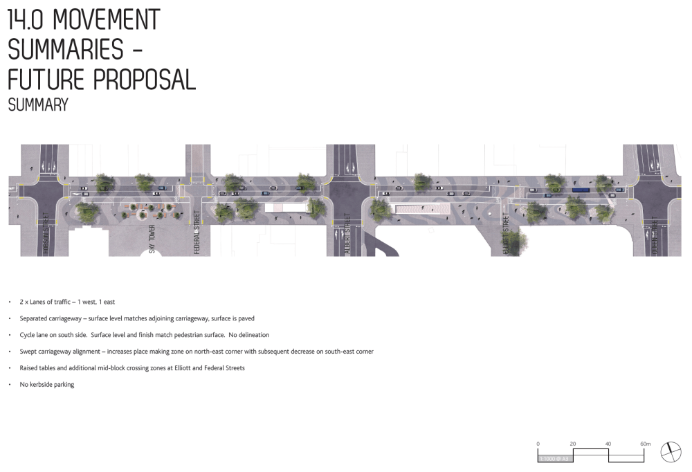
Last week Councillor Darby sent me a whole stack of work done by the Council on the Linear Park, I will reproduce some of this here, but I urge everyone interested to follow the links below; there’s a huge amount of multilayered work showing how the proposal was arrived at and just how important it is:
The first point I would like to make is that I am talking here about the finished outcomes not the interim ones that need to accommodate work-rounds of the street disruption caused by the construction of the CRL. This is about the early 2020s; what is best for when the CRL is open and running, when the new buildings going up, and about to go up, in the city are occupied, and the pedestrian demands are many times greater than currently. It may seem a long way off, but contracts are being agreed now, and if we aren’t careful we will find ourselves locked into poor outcomes that will prove expense to fix. And, remember, this is dividend time; when the city starts to reap the reward of all the expense and disruption of building the CRL itself. This is an important part of why we are doing it: to substantially upgrade and improve every aspect and performance of the whole city as possible, including its heart. Transport infrastructure is a means to an end; not an end in it self.
Second is to suggest that it has been perhaps a little unhelpful that Council called this reclamation of city street a ‘Park’. I can see why they have, this is a repurposing of space from vehicle use to people use, and it does offer the opportunity for new high quality design elements, which is similar to what happens in a park. But I think this undersells the full complexity of what is happening here. There is a great deal of functionality and hard rationality in this scheme, as well as the promise of beauty and the city uplifted.
The place to start is the CEWT study [City East West Transport Study]. This set a very rational and ordered taxonomy of the Centre City east west streets, concluding that Victoria St’s priority will need to shift to a strong pedestrian bias, be the only crosstown cycle route between K Rd and Quay St, and enable a reduced but still efficient general traffic load:

Note that east west bus movements are kept to Wellesley and Customs Sts. This greatly helps Victoria St’s space location as shown below. It is becoming clear that AT now want to return buses here. I believe this is a very poor idea, and will unpack why in a following post. So many poor place and pedestrian outcomes follow directly from trying to get both buses and general traffic trough inner Victoria St, and it is still a very hard street to try to shove buses through in terms of their own functionality, and that of the other general traffic. As well as leading to the total deletion of the only Centre City east/west cycle route. Here is how it was shown in CEWT:

Now turning to the newer iteration from the docs linked to above. The key issue is that the sections of the ‘Park’ around the station entrances on Victoria are focussed on pedestrian capacity rather than place amenity:
Not a park as in a verdant garden, but largely hard paving for efficient and high capacity pedestrian movement under an elevated tree canopy. Very much an urban condition tailored to met the massively increased pedestrian numbers that we know will be here. Particularly from the CRL itself, but also from the rapid growth and intensification of the whole city centre as it builds up around them, and of course the considerable bus volumes on Albert and Bus or LRT on Queen St. At the core this is simply classical ‘predict and provide’ that surely even most unreconstructed and obdurate of engineers can understand. Meeting projected pedestrian demand; not just an aesthetic upgrade, though why we wouldn’t do that while we’re at it, I can’t imagine.

Because this station sits directly below the greatest concentration of employment in the whole country, as well the biggest educational centre, retail precinct, hotel location, and the nation’s fastest growing residential population, we can expect these entrances to immediately be very busy. The plan on opening is for there to be 18 trains an hour each way through this station all with up 750 people [or even 1000 when really packed] alighting and another load boarding, all milling a round; waiting or rushing. And mixing on the streets with all the other people not even using the system. This will make for a very busy place. Their will be thousands of people walking around here at the peaks. Many more than those that use the entire Hobson/Nelson couplet in their cars over the same period. This will need space. Furthermore urban rail systems are very long term investments, what may be adequate for the first few years of the CRL is unlikely to sufficient for the years ahead, let alone decades. There is a clear need for the space for this human traffic to be generous to begin with, to err on the side of spare capacity. This really is no moment to design for the short term, once built that tunnel isn’t moving.


So has any work been done to picture this demand? Yes. Though to my inexpert eyes this looks a little light:

In particular the pedestrian traffic heading north, ie crossing Victoria St looks underrepresented. There will be no entrance to the station on the north side of Victoria street. Everyone heading that way has to come out of one of the east/west exists and crossover at street level. The document above does at least point out the pinch points between the exits and buildings on Victoria. And it is these that AT must be planning on squeezing further to get four traffic lanes back into Victoria St. One lane comes from deleting the cyclists, and the other must be from squeezing pedestrians passing the stations entrances. Just don’t AT; therein lies madness, very expensive to move a station entrance once built. And frankly a 5m width here between hard building edges is already tight and mean. Somewhere in AT the old habits of not really expecting people to turn up and low use of the very thing the agency is building seem to have crept back up to dominate thinking, and all for what? Vehicle traffic priority. The most spatially inefficient use of valuable street space in the very heart of our transforming city.
The extra wide pedestrian space that the Linear Park provides doesn’t just have value immediately around the station portals. Stretching up to Albert Park and the University beyond to the east and up on the flat plateau of western Victoria St offering a good pedestrian route to the new offices and dwellings on Victoria St West and Wynyard Quarter beyond. But as the distance increases from the big sources of pedestrians then the condition of the amenity can become more place focused and more planting and ‘lingering’ amenity can be added, yet it will still need to primarily serve these Active Mode movement functions well:

And it is important to acknowledge this is a ‘substantial change’ from present condition. The Council recognise, and it is impossible to disagree, that there is nothing to be gained by trying sustain the status quo here. The CRL is brings huge change to the city and how it is used and this needs to be reflected in very nature of our streets as well as in our travel habits:


The Centre City Cycle Network is hopelessly incomplete without some way to access both the Queen St valley and Victoria Park from the Nelson St Cycleway. And if not on Victoria then where? Not with all the buses and bus stops on Wellesley St.
And lastly, other than the never fully successful Aotea Square there has been no new public realm in the City Centre since the Victorians set out Albert, Victoria, and Myers parks. There are now many more people living, working, and playing in the city than ever before, and other than repurposing, or burying, motorways, or demolishing buildings, the streets are the only chance to provide quality space for everyone. This is so much more valuable than slavishly following last century’s subjugation to motor vehicle domination. We know better than this now. Vehicles will fit into whatever space we provide and people will flood the rest. And the later is the more valuable street-use for a thriving, more inclusive, and competitive, and sustainable urban centre to lead the nation this century.


 Processing...
Delays delays delays. No progress, no plans, just delays.
Patrick, good work in exploring whether this project delivers what Auckland wants.
I still believe that the starting position of 27% car mode share by 2046 is unambitious and does not seem in keeping with Council’s aim to have a much more pedestrian focused city. (Don’t get confused by the percentage drop from the present, because as the number entering the city by PT increases this would mean more cars, if the current mode share was to be preserved). As long as 27% is the starting point then presumably projects will be designed to achieve that target. Maybe Auckland should have a city mode share target of half the current target?
If even heavily populated cities like Buenos Aries can turn complete streets like Florida St over to pedestrian use then why can’t Auckland?
I am also concerned that AT don’t seem to be having a conversation about other factors that should accompany mode reduction. As a commentator said recently, why shouldn’t AT look at selling car park buildings? if car mode share is decreasing will AT need so many parking buildings. At night they struggle to fill them now with one car park only charging $2 per hour. Let’s have a comprehensive discussion about making Auckland city more liveable.
John I agree completely, but now Access for Everyone has been officially adopted that target is well out of date. The city centre masterplan refresh underway now must send this number down towards 10% to be consistent.
But regardless of whatever targets can be got past the endlessly change-resistant gatekeepers in our institutions I have no doubt we are heading to a much more transformed and more vehicle free future than is imagined in that document.
Patrick, I suspect that 10% would require taxi and ubers to also be removed from the city. As you know these two modes have been largely blamed for re-congesting London post the congestion tax implementation. Is that desirable or possible?
And then the really big question -what time frame? My thinking is that there should be more than adequate capacity post CRL and the Mangere light rail.
This plan has potential to be so good. Let hope it is not stuffed up.
The design was broken from the start anyway. Customs/Quay would have been much better off as a 1 way pair, releasing more road space to become public pedestrian space. You could have had linear parks on Quay and Customs as well as Victoria.
Instead we get some compromised fantasy option, plus with Customs being an even busier, more polluted traffic severance between the waterfront and the rest of the city.